Are you looking for easy hikes in the Biella region to unplug and immerse yourself in nature without too much effort? The Biella area offers an extraordinary landscape, ranging from peaceful lakes to the pristine woods of the Cervo Valley, up to the pastures of the Elvo Valley. In this guide, I have selected 3 of my favorite walks, perfect for those seeking simple, relaxing hiking trails rich in history.
Where it starts: From Biella, head to Occhieppo Inferiore and Occhieppo Superiore, then continue towards Sordevolo. Carry on through Sordevolo, ignore the turning for Verdobbio/Pollone and keep climbing the main road (the road to San Grato). At the Prera–San Grato fork, take the San Grato branch. Park along the road after the bend behind the church. About 25 minutes from Biella.
This is absolutely one of the most fascinating easy hikes in Biella. Starting from the church of San Grato in Sordevolo, you will enter a mixed forest offering breathtaking views of the plains, the Serra morainic amphitheater, and the Sanctuary of Graglia.
The trail guides you past well-kept farmhouses, pastures, and babbling streams (like the Solasca stream), until you emerge in front of an architectural jewel nestled in the mountains: La Trappa. This imposing 18th-century stone building, originally a textile mill and later inhabited by Trappist monks fleeing the French Revolution, is a magical place where time seems to stand still.
The return journey, slightly downhill along the Tracciolino road and Pian Paris, completes a perfect loop for those who love combining nature with local history.


Where it starts: From Biella, head to Cavaglià and at the roundabout with the horse turn right, following signs for Viverone and/or Ivrea. Stay on the road as far as the roundabout with the large blue Viverone lettering and take the first exit. At the next roundabout, where the old washhouse used to be, go straight on and after about 80 metres turn left, avoiding the road to Rolle. This brings you to Viverone's parish church, where you can leave the car in the car park in front of it. 35 minutes from Biella.
If you prefer a lakeside atmosphere, this route is ideal. Starting from the church of Viverone, we venture into an itinerary that blends history with relaxing landscapes. You will discover the Ricetto di Rolle (or Viverone), an ancient 15th-century defensive structure of which a crenellated tower survives, before joining an incredibly scenic dirt road.
From here, the view stretches from the snow-capped Alps all the way to the lake. This trail is a true stress-reliever: you will walk through a quiet, uncrowded area, passing through vineyards, meticulously kept olive groves, and ancient Piedmontese farmhouses like Cascina Tizzone. The return takes place on a section of the Via Francigena, completing a rewarding loop suitable for anyone.


Where it starts: From Biella, cross the “Ponte Cervo” at Chiavazza and follow the SP100 as far as Campiglia Cervo. Leave the car in the car park at the far end of the village. 20 minutes from Biella.
The Cervo Valley is a territory that must be explored on foot to understand its true essence. This “orange loop” is an easy walk connecting Campiglia to two splendid historic hamlets. You will ascend gently on perfect, ancient mule tracks, a testament to the incredible skill of local stone artisans.
The trail takes you to Sassaia, a true jewel of mountain architecture made up of small squares, washhouses, and syenite fountains, before crossing beech woods to reach Piaro. It is an almost entirely shaded walk, perfect for summer Sundays. You will feel like you have taken a step back in time, admiring restored votive pillars and monumental trees, breathing in the most authentic soul of the Biella region.


All 22 walks in the Biella region
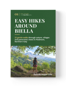
The three walks described above are taken from the guidebook «Easy Hikes Around Biella», which collects 22 of them grouped by area: Valle Elvo, Valle Oropa, Valle Cervo, the Bessa and the Serra, the Biella hills and Lake Viverone. This is the full list, with distance, elevation gain, walking time and difficulty for each. Route and area names are kept in Italian, as they appear on the trail signs.
| Route | Area | Distance | Elevation gain | Walking time |
|---|---|---|---|---|
| Anello da Sordevolo alle Salvine | Valle Elvo | 9,96 km | 574 m | 5 h 30 min |
| Anello da San Grato di Sordevolo alla Trappa | Valle Elvo | 7,74 km | 348 m | 3 h 30 min |
| Anello da Sordevolo al Santuario di Graglia | Valle Elvo | 11,35 km | 527 m | 5 h 30 min |
| Anello da Graglia al Monte Rotondo | Valle Elvo | 5,93 km | 149 m | 2 h 30 min |
| Anello da Donato Lace | Valle Elvo | 5,15 km | 145 m | 2 h |
| Anello da Netro | Valle Elvo | 4,62 km | 139 m | 1 h 40 min |
| Anello da Occhieppo Sup.re alla Cammuzzaglia | Valle Elvo | 6,86 km | 180 m | 2 h 30 min |
| Anello dalle Cave del Favaro | Valle Oropa | 9,18 km | 306 m | 3 h |
| Anello da Oropa all’Alpone Inferiore | Valle Oropa | 7,32 km | 184 m | 3 h |
| Anello da Momproso all’Alpe Falcine | Valle Oropa | 4,09 km | 262 m | 2 h |
| Anello da Campiglia Cervo a Sassaia e Piaro | Valle Cervo | 3,73 km | 209 m | 2 h 30 min |
| Passeggiata da Forgnengo a Fienbello | Valle Cervo | 7,10 km | 201 m | 2 h 30 min – 3 h 30 min |
| Anello da Case Falletti alle cascine della Sciura | Valle Cervo | 5,14 km | 256 m | 2 h 30 min |
| Anello in Bessa | Bessa e Serra | 6,80 km | 99 m | 2 h 30 min |
| Anello da Torrazzo a Magnano | Bessa e Serra | 15,94 km | 278 m | 6 h |
| Semianello da Torrazzo alla Cascina Malata | Bessa e Serra | 9,56 km | 141 m | 3 h 15 min |
| Semianello dalla Broglina a S. Stefano di Sessano | Bessa e Serra | 12,47 km | 373 m | 5 h |
| Anello da Ronco Biellese al Brich di Zumaglia | Colline Biellesi | 5,16 km | 234 m | 2 h 15 min |
| Anello da Ronco Biellese al Castello di Valdengo | Colline Biellesi | 7,96 km | 159 m | 3 h |
| Anello da Zumaglia a Villa Piazzo di Pettinengo | Colline Biellesi | 6,08 km | 219 m | 3 h |
| Anello da Viverone tra vigneti, lago e cascine | Lago di Viverone | 4,66 km | 82 m | 2 h |
| Anello da Cavaglià a Morzano | Lago di Viverone | 7,73 km | 66 m | 2 h 45 min |
Take all 22 routes with you
Every route in the table is described step by step in “Easy Hikes Around Biella”: how to get there, the landmarks along the trail, a map, and a QR code with the GPS track to follow on your phone.